About Deer Creek GIS
Deer Creek GIS provides mapping and media design services to inform modern land management. We believe that while everybody looks out through their own political lens, there is only one physical reality – the conditions on the ground. We use technology, storytelling, photos, and maps to bridge the divides, bringing people to the table with a common frame of reference.
History
Deer Creek GIS was founded in 2011 by Erika and Zeke Lunder. Zeke has been involved with land management and mapping since 1990, when he worked as a seasonal forestry tech on the Lassen National Forest. A love of working outside, maps, and art turned into a geography degree and a career in wildfire, digital mapping, and web design. In the last 20 years, Mr. Lunder has worked on mapping projects across most of the Western States, in Alaska, and New Zealand.
From 2000-2010, Mr. Lunder managed NorthTree GIS – a division of NorthTree Fire International. During this decade, Mr. Lunder’s division provided over 45,000 hours of onsite emergency GIS consulting to government agencies and private clients. In January 2011, NorthTree Enterprises reorganized and closed their GIS division. We learned a lot working there, and carry forth their vision: Give knowledgable people quality equipment, maintain and ethical business, and you will get an exceptional product.
Some past GIS projects that Deer Creek staff have worked on:
Sacramento River Tributaries Projects 1998-2000
CSU, Chico Research Foundation
Provided GIS and GPS mapping support to CALFED-funded projects including wildland road erosion assessments, wildfire and fuels management planning, and the development of watershed existing conditions reports for the Big Chico, Butte, and Deer Creek Watersheds. Tasks included oblique aerial photography, map editing, landowner outreach, and public speaking on watershed issues in Butte and Tehama Counties, California. General emphasis was on evaluating current conditions and assessing potential threats to water quality and salmonid fisheries in foothill watersheds between Battle Creek and the Feather River.
McNabney Marsh Vegetation Mapping Project – 2011
Client: Mountain View Sanitary District
Used current Infrared aerial photography and field botany data to create a vegetation map for a 200 acre marsh in Martinez, CA. Conducted accuracy assessments, rectified aerial imagery to map-scale, and wrote a discussion in final report.
Westwood Millsite Reuse Survey – 2011
Client: Mountain Meadows Conservancy
Used 1941 and current aerial photography to design a poster showing the locations of buildings and facilities at the historic Westwood, CA, Mill Site, and current conditions. This work and our aerial photography accompanied a report that developed strategies to remediate potential pollution at the site, and convert the property to a more beneficial use.
Butte Creek Aerial Atlas
Client: Friends of Butte Creek
Captured and geotagged aerial photographs showing landscape and infrastructure features along Lower Butte Creek, in California’s Sacramento Valley.
Google Map for Butte Creek Aerial Atlas
View Larger Map
McKenzie Meadows Aerial Atlas Aerial Atlas
Client: Mountain Meadows Conservancy
Captured and geotagged aerial photographs showing landscape and erosion features in the Mountain Meadows, Lassen County, CA.
Google Map for McKenzie Meadows Aerial Atlas
View Larger Map
Past projects that our staff worked on while employed by NorthTree Fire
Lassen Foothills Fire Management Plan – 2004/5
The Nature Conservancy, Dye Creek, California
Contact: Richard Reiner – 530-343-7085
Mapped vegetation condition and developed fire management recommendations to reduce noxious weeds and benefit native species on the Nature Conservancy’s Lassen Foothills project area (Eastern Tehama County, California). Conducted oblique aerial photography missions and ground surveys and collaborated with US Forest Service staff to develop landscape-scale strategies for effective wildfire management across the 900,000 acre project area.
Almanor Basin Watershed Interactive Mapping – 2005
Sierra Institute for Community and the Environment
Contact Jonathan Kusel, Executive Director – 530-284-1022
Used GIS software and wrote code to create a map-based interactive watershed information system for the Lake Almanor Basin, in Northeastern California. The intention of this project was to allow residents of the area to access water quality information collected for the lake. Toward this end, we installed our interactive watershed tour on public computers hosted at the Chester Library. The final product is available for download (Google Earth software required) at the Sierra Institute’s website.
Cameron Park Community Wildfire Protection Plan – Summer 2006
Eldorado County Firesafe Council, California
Contact: Barry Callenberger – 530-644-6513
Our staff conducted parcel-level surveys for over 7,500 individual homes in the Sierra Nevada Foothills. Work was conducted from a moving vehicle using GPS and a laptop running ArcGIS. 12 attributes were collected for each structure, including: Building and roofing materials, vegetation attributes, fire hazard, and firefighter access. Our staff surveyed both sides of the road at once, and generally mapped 1,000 structures per day. Survey results (delivered to county employees via open-source interactive web-based maps) were used to prioritize code enforcement actions.
Example of Data Collected in Cameron Park Wildfire Hazard Survey
View Larger Map
Online GIS and Asset Management System – October 2008
Private client – Location: Monterey, California
Our staff developed an interactive GIS for a 5,000 acre property. This involved GPS mapping of all man-made features on the property, digitizing paper base maps, reprojecting CAD surveys, and writing scripts to automate the production of Google Maps digital overlays. Approximately 4,000 digital photos were geotagged and associated with attribute data for 2,800 datapoints. Our staff mapped all highway signs on approximately 15 miles of public road, capturing sign-type, location, condition, and size information using Trimble GPS units with laser rangefinders.
Final product was delivered as interactive Google Maps layers – users can click points on the map to see photographs and descriptions for each mapped feature.
Fuels Management Planning for Lick Observatory – Mount Hamilton, California
Client: University of California
Developed a plan to reduce wildfire hazard to buildings and infrastructure across 45 mountaintop acres East of San Jose, CA. Wrote technical materials for $500k FEMA hazard mitigation grant, and once project was awarded, monitored work of brush clearing crews.
This image from http://northtreefire.com
Digital Atlas for the Sacramento River Watershed – November 2007 – November 2010
Client: Sacramento River Watershed Program
Contract Administrator – Peter Tittmann – Technical Director (707) 849-4135
Members of our staff designed, programmed, and implemented a regional enterprise GIS system for watershed coordinators, agency administrators, and the general public for the 27,000 square mile Sacramento River Watershed Program.
This project included the development of spatially-enabled web-based photo and document management, data export tools, and FGDC compliant metadata cataloging tools. User-contributed photos and videos are available via Google Maps interface at http://sacriver.org.
The online GIS is based upon ESRI’s ArcIMS software, and features over 200 layers including current aerial photo image catalogs, historical maps, and LANDSAT imagery. The site is online at http://srwp.org/imf/imf.jsp?site=SWIM
Three views of the Colusa Flood Bypass – from ‘SWIM’ mapping website.
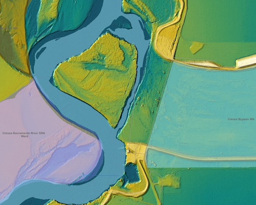
LIDAR terrain model of Colusa Bypass
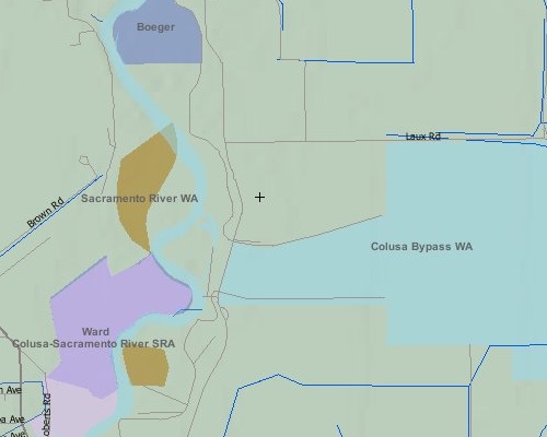
Land Ownership around Colusa Bypass
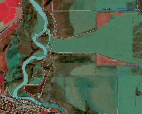
LANDSAT image of Colusa Bypass after 1997 floods
General References for Zeke Lunder and Deer Creek GIS
Jim Schmidt – GIS Coordinator, US Forest Service, Stanislaus National Forest
209-532-3671 x220 – jschmidt@fs.fed.us
Our staff have worked with Jim providing GIS mapping support to Incident Management Teams on large wildfires. In this capacity, our staff developed GIS databases from multiple sources, maintained database integrity by enforcing filenaming conventions, performed regular data backups, and produced maps of actively burning wildfires in an accurate and timely manner.
Heather Taylor – GIS Coordinator, US Forest Service, Sierra National Forest
559-297-0706 x4873 – Tuesdays 559-877-2218 x3195 – M&F hmtaylor@fs.fed.us
Heather is the lead GIS tech for California Incident Management Team 3. Our staff have provided her with mobile GIS database management and mapping services during large wildfires since 2001 (same tasks as paragraph above).
Leah McFall – Former State GIS Coordinator – BLM Alaska
541-880-8319 – lmcfall@e.coolworks.com
Leah is the lead GIS tech for Pacific Northwest Incident Management Team 3. Our staff have worked for her extensively providing contract GIS services during large wildfires in California, Oregon, and Washington.
Dr. Tom Griggs – Senior Restoration Ecologist, River Partners
530-894-5401 tgriggs@riverpartners.org
DCG President Zeke Lunder worked with Tom Griggs while employed by the CSU, Chico Watershed Projects. Tom is familiar with our fine-art cartography and oblique aerial photography skillset.
Robin Wills – Western Region Fire Ecologist, National Park Service
530-898-9826 robin.wills@nps.gov
Robin is familiar with our landscape-scale wildfire hazard assessment and illustration work. We have worked with him on wildfire history studies and other fire ecology fieldwork. Also, we developed a textbook illustration and contributed aerial photography to a chapter that he authored on the historic fire regimes of California’s Central Valley for the UC Press’ Textbook ‘Fire in California’s Ecosystems’.
Barry Callenberger – US Forest Service Pacific Southwest Region, Deputy Director for Fire and Aviation (ret).
530-644-6513 wldlnd@aol.com
Barry has collaborated with Deer Creek GIS staff on wildfire hazard investigations and wildland fuels mapping projects. Clients have included the Tahoe Basin Firesafe Council, the Nature Conservancy of California, and the University of California.
Resume ~ President and Lead GIS Developer – Zeke Lunder
Education
California State University, Chico – 1996 – Bachelor of Arts in Geography
Research Assistant – Spring 1998 – Summer 2000.
University of Alaska, Fairbanks, 2000 – Summer Institute in Ecosystem Ecology.
Fire ecology and mapping experience in the Sierra Nevada Mountains, California Coast Range and Foothills, Great Basin, Southern Cascades, Northern Rockies, Pacific Northwest, and Alaska.
Skills Include
Predictive spatial modeling, topographic analysis and modeling, digital image pre-processing, including geo-registration, orthorectification, and atmospheric/radiometric correction, image analysis and classification, multivariate statistical analysis for modeling and image processing, database population and auditing, cartography, project management, training, technology planning, web development, and creation of FGDC-compliant metadata.
Relevant Experience
Chief of Operations – Deer Creek GIS ~ 2011-present
Providing leadership, strategy, and labor to launch and sustain a new GIS consultancy. Cartography, database design, training, web development, policy and procedures, IT system design, communications, management and metal fabrication responsibilities.
GIS Manager – NorthTree GIS ~ 2000 – 2010
As GIS manager for NTFI, Mr. Lunder designed, built, and staffed mobile GIS mapping facilities for incident mapping, supervised and trained over 50 call-when-needed GIS techs, and compiled over 3,000 hours experience as wildfire GIS Specialist on 35+ large wildland fires in the Western U.S. His staff provided over 45,000 hours of onsite GIS services to emergency clients including CAL FIRE, the US Forest Service, and the Union Pacific Railroad.
Non-emergency work included development of ArcIMS-based online GIS services and metadata catalogs, database project architecture, and design of web-based spatial information systems including the Sacramento River Watershed Digital Atlas – http://sacriver.org/wim and a Google Earth-based watershed information system for the Lake Almanor Basin –http://sierrainstitute.us/Almanorvirtualtour.html
Other technical skills include oblique aerial photography, GPS survey design, data dictionary creation, GPS-enabled photo-mapping, Google Maps API programming, UNIX/Linux server administration and file management, automated digital photo processing, and administration of web-based project task/project management systems.
Wildland Fire Planning Specialist/Project Manager – CSU, Chico Watershed Projects, 1998-2000.
Authored fire management chapters for U.S. Fish and Wildlife Service-funded watershed assessments on foothill watersheds in the Northern Sacramento Valley area, Northeastern California. Used LANDSAT TM imagery, timber harvest history GIS data, flew recon/aerial photography missions, and conducted field-surveys to map forest fuel accumulation and fire hazards. Led GPS mapping crews to survey stream crossings on logging roads.
Silviculture Technician and GIS/GPS specialist – USDA Forest Service – 1995-1997.
Performed vegetation/stand inventories, marked biomass-thinning/shaded-fuelbreak thinning projects, GPS mapped stand boundaries. Fought district wildfires and taught ArcInfo GIS to district staff.
Software Skills
ESRI ArcMap, ArcView, ArcInfo, ERDAS, Idrisi, Google Maps/Earth API, UNIX, Photoshop, MS Office. Scripting experience in ESRI AML, .php, Javascript, and Visual Basic. Professional graphic designer and cartographer, with Gold Medal wine label design at California State Fair.
Selected Publications
1999 – Big Chico Creek Existing Condition Report – Wildfire Management
1999 – Butte Creek Existing Condition Report – Wildfire Management
1999 – Butte Creek Watershed Road Survey
2000 – Deer Creek Watershed Fire Management Framework
2002 – Morro Bay Estuary Watershed Fire Management Plan
2003 – Lassen Foothills Fire Management Plan – for The Nature Conservancy
2004 – Plumas County Hazardous Fuel Assessment and Strategy
2005 – Cameron Park Community Wildfire Protection Plan – Eldorado County
2005 –$500,000 FEMA Grant for fuels reduction at Lick Observatory
2006 – Map illustration “Fire in California Ecosytems” – UC Press.
2007 – Map illustrations for book “The Thirtymile Fire” by John N. Maclean
2007 – Almanor Basin Watershed Information System – online interactive GIS
2007 – Wildfire Assessment for 150,000 acres of timberland in Oregon
2009 – Sacramento River Watershed Digital Atlas – http://sacriver.org/wim
2010 – Sacramento River Watershed “Roadmap for the Future” Atlas Editor
Detailed project information
Big Chico Creek Existing Condition Report – Wildfire and fuels management section
Researcher/author
1998 For USFWS
Wrote fire management chapters for U.S. Fish and Wildlife Service-funded watershed assessments on foothill watersheds in the Northern Sacramento Valley area, Northeastern California These chapters assessed fire protection infrastructure and access issues, critiqued the California Department of Forestry and Fire Protectionís satellite-based fuels mapping and risk-assessment methodology, interpreted existing fire history studies and mapping, identified areas of high potential fire severity, and mapped existing fuelbreak projects.
Butte Creek Existing Condition Report – Wildfire and fuels management section
Researcher/author
1998 For USFWS
These chapters assessed fire protection infrastructure and access issues, critiqued the California Department of Forestry and Fire Protectionís satellite-based fuels mapping and risk-assessment methodology, interpreted existing fire history studies and mapping, identified areas of high potential fire severity, and mapped existing fuelbreak projects.
Upper Butte Creek Watershed Road Survey
GPS Mapping/GIS coordinator
1999 For USFWS
An assessment of sediment production from forest roads in the Upper Butte Creek Watershed ñ Northern California Walked 50 miles of forest road, surveyed approximately 250 stream crossings, supervised and scheduled field crews, and taught dirt-bike GPS mapping techniques.
Deer Creek Fire Management Framework
Project Manager/author
1999 For CALFED/EPA
In 1999 the Deer Creek Watershed Conservancy received a grant to identify potential erosion hazards associated with high-severity wildfire in the watershed and to make recommendations on the feasibility of implementing a landscape-level network of shaded fuelbreaks. I compiled and analyzed existing GIS data, conducted field-surveys, and used ground observations to interpret stand composition and densities on oblique aerial photography collected from a light plane. Facilitated meetings with land managers and biologists, and published a final report.
RAMS (Risk Assessment and Mitigation Strategies) Fuels Management Program Assessment
GIS Lead
2001 For Battle Mountain District, BLM
GIS analysis for landscape-scale fuels management project prioritization Used LANDSAT and other GIS data to evaulate existing veg. Used GIS to assess response times for fire resources, and to characterize threat of human wildfire ignitions over 10 million acres of public land
Morro Bay Estuary Watershed Fire Management Plan
Project Manager
2001 For MBNEP
Identified high hazard areas and potential strategies for integrating fire and fuels management into long-term ecological restoration projects within the Morro Bay Estuary watershed
Whiskeytown Fire History Study
Project Manager
2001 For NPS
Designed and mapped fire history research plots, coordinated field crews responsible for collecting and preparing fire-history tree-ring cross-section samples for Whiskeytown National Recreation Area (NPS).
RAMS (Risk Assessment and Mitigation Strategies) Fuels Management Budget Assessment
GIS Lead
2002 For Elko and Ely Districts, BLM
GIS analysis for landscape-scale fuels management project prioritization Used LANDSAT and other GIS data to evaulate existing veg. Used GIS to assess response times for fire resources, and to characterize threat of human wildfire ignitions over 25 million acres of public land
Fire Management Plan for Inks Creek, Tuscan Buttes, Dye Creek & Vina Plains Units, The Nature Conservancy, Lassen Foothills Project
Project Manger
2003 For The Nature Conservancy
The plan delineated fire management units across 90,000 acres of conservation rangeland, identified unit-specific fire management objectives, and prioritized units targeted for prescribed fire. It also included unit fire prescriptions and plans, along with initial documentation required under by the California Environmental Quality Act (CEQA), for priority burn units. Field assessments, oblique aerial photography, satellite imagery, and existing information from The Nature Conservancy, Denny Land & Cattle Company, CDF, Northtree Fire and other sources were used to evaluate landscape-level fire management concerns.
Tahoe Basin Fuels Management Plan
Mapping Consultant
2004 For Wildland Rx
Collected field data on surface and aerial forest fuels
Plumas County Hazardous Fuel Assessment and Strategy
Mapping Coordinator/co-author
2004 For Firesafe Council
Collected field data on surface and aerial forest fuels.
Cameron Park Community Wildfire Protection Plan For the Eldorado County Firesafe Council
Mapping Coordinator
2005 For CDF
Developed spatial database and custom GIS interface for rapid onsite assessment of wildfire hazard in subdivisions Collected data for over 7,000 individual parcels in 9 field days, used survey data to develop base data for use in fire behavior modeling using the FARSITE program
Whiskeytown National Recreation Area Historic Vegetation Map
Project manager
2005 For NPS
Developed map/poster of historic vegetation at Whiskeytown NRA using original vegetation observations from General Lands Office surveys conducted in 1870s
Map illustrations
Researcher/Cartographer
2006 For Henry Holt Publishing Co.
Developed maps for book on a wildfire that killed 4 firefighters.
Map illustration
Cartographer
1998 For CSU, Chico
Developed map of John Bidwell’s historic route during the first European journey over the Sierra Nevada Mountains
Presidential Briefing Map
Designer/Cartographer
2003 For California Department of Forestry and Fire Protection
Produced a large oblique satellite image poster showing the areas burned by three large fires in San Diego County, in fall of 2003. This map was used to brief Gov. Gray Davis, Gov. elect Schwarzenegger, and President Bush.
Website redesign – www.northtreefire.com
Project Manager/Content Developer
2004-2006 For NTFI