California has a lot of fires, but unless you have actually seen your neighborhood burn, it can be hard to imagine it happening. This year’s fires remind most of us how helpless we can be when wind, drought, and fire come together. Learning about historic fires in your area is a good way to come to grips with the relative hazard of your community. We use maps like the one below to design brush cutting projects, plan prescribed burns, and develop other community wildfire safety projects.
Contact us if you are interested in learning more about wildfire hazards in your area.
2017 California Wildfires
This map uses data from the State and Federal Wildfire Management Agencies to show large fires that burned in 2017. (Takes a minute to load)…
ArcGIS Map by Deer Creek GIS.
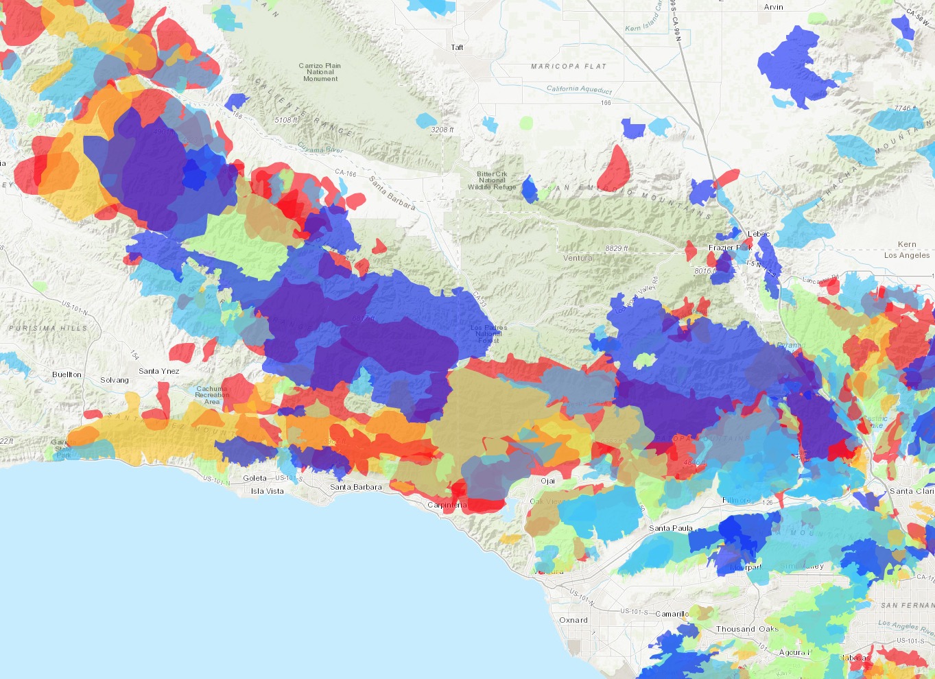
California Wildfire History 1900-2016 (fires over 250 acres shown)
Map of historic fires (1900-2016) in the Santa Barabara/Ventura area. Click the dynamic map, below to see dates and acreages for historic fires.
ArcGIS Map by Deer Creek GIS.
California Wildfire History 1900-2016 – Number of Overlapping Fires
Many areas in California have burned more than 5 times in the last century. Before fire suppression began in the 1900s, many areas burned every 5-10 years, ignited either by lightning, or by people. Many of the areas which have NOT burned on this map now have the highest hazard of severe fires, as they have 100+ years of accumulated dead brush and woody debris.
ArcGIS Map by Deer Creek GIS. Thomas Fire shown in Black (12/11/2017). Due to weird webmap glitch, fire overlaps only displayable at this scale. Click here for a fullscreen version.
Adapting to Wildfire – Lick Observatory Wildfire Safety Project – 2016-17
Client: University of California
Removing or reducing burnable materials around your home or property is a reliable way to lower the risk of wildfire losses. Here is an example of a high-complexity wildfire safety vegetation management project we recently designed. DCR wrote detailed specifications, helped choose a contractor, and supervised implementation. This project cut and removed hazardous wildfire fuels around a major mountaintop observatory outside of San Jose, California.
Working with Fire – Using Prescribed Fire to Reduce Hazardous FuelsAlong with our parent company, Firestorm, DCR helps communities understand prescribed burning and empowers them to take on their own burning projects. This video shows crews lighting controlled burns to remove brush and tree limbs in an old burn scar near Orleans, California. Click here to learn more about some of the people who are making this happen in the Klamath Mountains. DCR also uses UAVs for aerial observation and monitoring during prescribed fires.
California Direct Protection Areas
In response to fires which threaten everything we have built, California has devised one of the most advanced firefighting organizations in the world. Here is a map showing which agency takes the lead when wildfires break out in any specific part of the State.
ArcGIS Map by James Gannon, Ca. BLM CDD
View Fullscreen
How can we learn to live in better balance and resiliance with fire? Explore our website to see some of the ways we work to face this challenge.