Statement of Qualifications
This information can also be downloaded as a PDF.
Established in 2011, Deer Creek Resources (DCR) is the resource management division of Firestorm Wildland Fire Suppression, Inc. Firestorm has been in the wildland fire and forestry business since 1996, and is California’s largest wildland firefighting contractor with over 250 federally-qualified wildland firefighters.
In addition to wildland firefighting, Firestorm/DCR is a leader in prescribed fire, wildland fire hazard mitigation and forestry services. We have completed forestry projects on over 30,000 acres, including thinning, piling, mastication, fuelbreak construction, ecological restoration, postfire erosion control, and trail maintenance. Additionally, we have successfully implemented ecological burning on over 225,000 acres on forests and rangelands throughout the United States.
DCR uses mapping, cutting-edge wildfire analytics, and applied science to help communities and landowners prepare for wildfire, manage watersheds and wildlands, and increase the transparency of land management decision making. We use our expert knowledge of wildfire behavior and land management to develop tangible wildfire hazard mitigation projects that affect real changes on the ground.
Our pre-fire plans improve public safety and benefit the landscape by:
- Identifying places where a wildfire might trap and kill people or destroy property
- Establishing priorities for fuel reduction and habitat restoration
- Integrating wildfire management with other land management objectives
- Reducing the risk of natural resource damage from severe fire and fire suppression activities
- Improving fire suppression effectiveness, as well as firefighter safety
- Preventing infrastructure losses/property damage during wildfire incidents
We use the following tools to assess fire hazard across landscapes:
- Geographic Information Systems (GIS)
- Cartography/mapmaking
- Satellite imagery, aerial photography, and LiDAR
- Tree-ring analyses (dendrochronology)
- Ground-based fuel mapping/surveys
- Numeric wildfire behavior models
- Qualitative data via interviews with knowledgeable locals
- Application of peer-reviewed science
Experience:
DCR’s wildfire mitigation experts have helped to develop wildfire pre-plans in the Lassen Foothills, Klamath Mountains, Lake Tahoe Basin, Central Coast, Klamath Mountains, and for Plumas, El Dorado, Amador, Monterey, Nevada, and Yuba Counties. Our staff developed a major hazardous fuels reduction project for Lick Observatory, on Mount Hamilton, in Santa Clara County, and also developed the Plumas County Hazardous Fuel Assessment & Strategy.
DCR has also provided professional GIS mapping services for major planning efforts including the South Lassen Watersheds Project, the Northern Sacramento Valley Integrated Regional Water Management Plan (NSV-IRWM) and Upper Feather River IRWM projects. Among other things, we have performed vegetation mapping of coastal wetlands for public agencies, developed field mapping applications for petroleum pipeline right-of-way inspectors, built map-based asset catalogs for major winery properties, and used aerial LiDAR data to conduct a timber inventory across 65,000 acres.
Project List:
Olympic Valley Community Wildfire Protection Plan – 2021-2022
CWPP identifies and prioritizes fuel reduction and wildfire prevention strategies within the Olympic Valley Fire Department’s service area. The plan addresses wildfire response, hazard mitigation, community preparedness, home hardening and structure protection. The CWPP will be used to guide the District’s Fuels Management Program and will allow the Olympic Valley community to be eligible for many wildfire prevention grant funding programs. The Olympic Valley Public Service District Board approved the CWPP in November 2022.
City of Chico Community Wildfire Protection Plan (CWPP) – 2021-2022
DCR mapped wildfire hazards and modeled potential fire spread within the urban area of Chico, California. Our project data scientists developed fire behavior model inputs from aerial LiDAR point cloud data, conducted interviews and public engagement, surveyed high-risk areas by foot and bike, and presented a final report as a PDF and web story map.
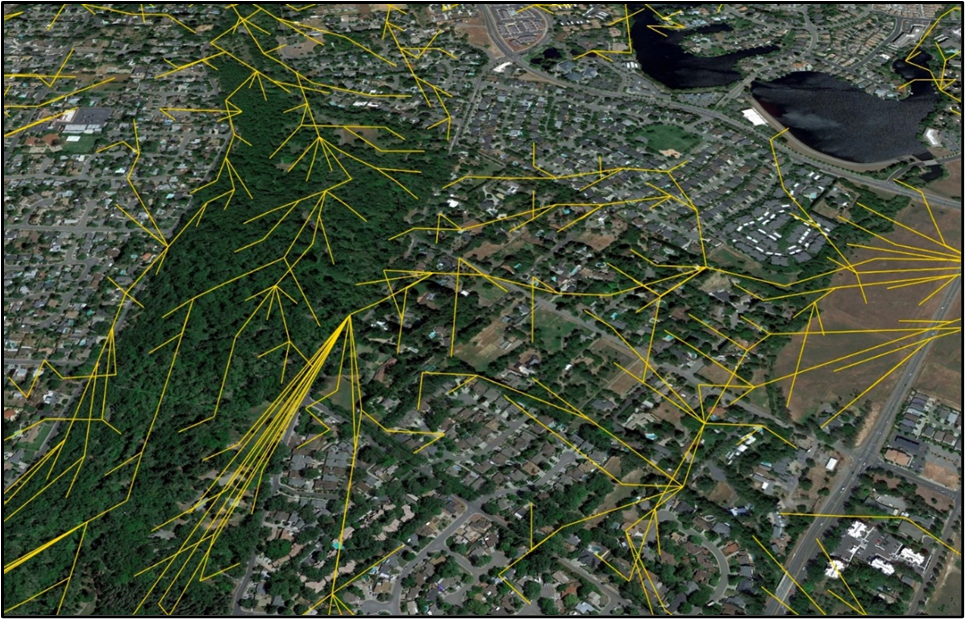 LiDAR-based wildfire spread vector mapping from DCR’s City of Chico CWPP.
City of Chico Vegetative Fuels Management Plan EIR – 2020-2021
DCR led the project’s wildfire hazard assessment team, using LiDAR survey data, aerial photos, and extensive fieldwork to map wildland vegetation, characterize fuel loading, summarize potential fire behavior, and develop vegetation management objectives for lands owned and managed by the City of Chico. DCR developed a burn plan to increase use of prescribed fire in management of City of Chico-owned lands.
Big Chico Creek Forest Management Plan – 2020
DCR provided fire behavior and prescribed burning specialists for planning and design of a 1,500-acre fuels reduction and forest health project in the Big Chico Creek Watershed, near Forest Ranch, Ca. This project is a collaboration between Butte County Fire Safe Council, CSUC’s Big Chico Creek Ecological Reserve, and several local landowners. This CEQA document will support partial implementation of a Forest Management Plan, also to be developed by BCRCD, covering 7,500 acres of the watershed. DCR mapped wildfire fuel loading conditions and developed large prescribed burning units in ponderosa pine and black oak forest areas.
Community Wildfire Risk Pilot Project – 2019
DCR provided a subject matter expert on a CAL FIRE Forest Health Program-funded project that seeks to reduce wildfire risk by providing better analytical methods and information for planning fuel treatments and implementing defensible space in the Wildland Urban Interface (WUI) and intermix.
Wildfire: Assessing and Preparing for Risks under Climate Change – 2019
The California Energy Commission is funding applied research and development to fill gaps in knowledge of fire science and apply that new knowledge to improve models to assess wildfire risk for grid operations and planning. DCR Director Zeke Lunder is contributing to the Extreme Weather & Wildfire Team, delivering advice on fire progression and fire weather events from an operational/field perspective; the Fuel Mapping & Fire Physics Team, delivering advice on field conditions during megafires; and the Wildfire Forecasting Team, delivering advice on the integration of risk forecasts into fire management and wildfire mitigation plans for investor-owned utilities.
Lick Observatory Wildfire Safety Project – 2016-17
DCR designed a wildfire safety vegetation management project, helped select a contractor, and supervised implementation. This project cut and removed hazardous wildfire fuels around a major mountain top observatory outside of San Jose, California.
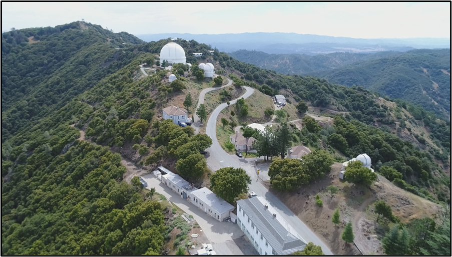 Lick Observatory Wildfire Safety Project
This project was tested when large wildfires burned across the area in 2020. All of the major buildings at the observatory survived with minimal air support.
Oroville Dam Spillway Response – 2017-2018
DCR provided rapid-assessment mapping on the Oroville Dam project site when the Spillway emergency began in February 2017. We created maps for the original emergency response teams, and did technical mapping work to support geological surveys of the bedrock beneath the spillway. Field geologists brought their field data to us, and a DCR geologist and mapping expert turned their field notes and hand-drawn maps into a high-resolution mapping dataset which was used to design the reinforcements and anchors for the new spillway.
Klamath River Prescribed Fire Training Exchange (TREX) – Ongoing since 2014
We are part of the core team organizing and executing annual prescribed fire projects in the Klamath Mountains. We help provide participants and communities along the Klamath River with experience and training on how to plan and implement controlled burns, protect communities from wildfires, and prepare for managing wildfires for resource benefits.
Western Klamath Restoration Partnership – 2015-2016
This project used airborne LiDAR data to characterize forest canopy structure for about 25,000 acres in the Klamath Mountains near Somes Bar, California. This mapping will be used to design thinning and prescribed burning projects to improve community and firefighter safety across this fire-prone part of the planet.
Upper Feather River Watershed Integrated Regional Water Management Plan
We provided mapping and website design to support a major planning project to establish priorities for water management-related projects across the watershed that provides 75% of the water used by the California State Water Project. One of our major tasks on this project was the design of a map-based document library.
Lake Tahoe Basin Community Wildfire Protection Plan Update – 2015
Cartography showing completed and proposed hazardous fuels reduction projects for fire districts throughout the Lake Tahoe Basin.
Sierra County Community Wildfire Protection Plan – 2015
We assembled a project GIS, facilitated community collaborative mapping meetings, edited community-provided mapping data, and produced planning and final report maps.
Integrating Traditional Ecological Knowledge into Community Wildfire Protection Planning – 2014
We facilitated collaborative mapping efforts with agency staff, Karuk and Yurok tribal members, and community practitioners of forestry. These meetings identified areas where large-scale cultural burning projects could improve acorn production, open up traditional travel routes, improve elk habitat, and protect communities along the Klamath. In addition, we participated in the 2014 Klamath River ‘TREX’ community-based prescribed burning training, filling mapping support, ignition, and firefighting roles.
Community Wildfire Protection Plan for the Yuba County Foothills – 2014
Mapped wildfire hazard, facilitated collaborative mapping meetings, and established and prioritized hazardous fuels reduction projects for communities in the foothills and mountains of Yuba County, California.
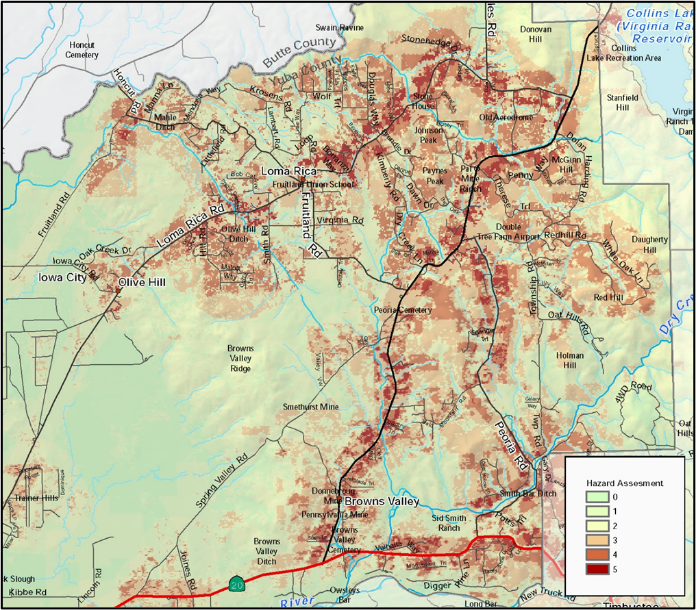
Example of DCR’s work on the Yuba Foothills CWPP to delineate mitigation project priority based upon modeled fire behavior, proximity to main roads, and assets at risk.